 Site Positing Unmanned Aircraft Systems
Industry-leading UAS mapping solutions for all you application needs.
|
|
Trimble Unmanned Aircraft Systems (UAS) Aerial Imaging solutions are designed to drastically reduce time and cost to collect aerial data and guarantee the reliability you need.
Aerial imaging can be used to perform a variety of tasks and produce a range of deliverables. Trimble UAS Aerial Imaging solutions are ideal for:
- Site surveys
- Topographic surveys
- Site planning
- Route planning
- As-builts
- Volume calculations
- Progress monitoring
|
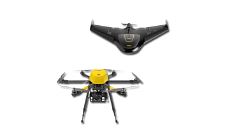
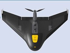
UX5
|
The Trimble UX5 Aerial Imaging Solution is setting the standard for fast and safe aerial data collection by offering a complete system with powerful technologies such as reversed thrust & automatic fail-safe procedures, a robust design and radically simplified workflow.
- Ensures optimal image quality along with maximum photogrammetric accuracy.
- Combines impact resistant foam structure and internal and external composite elements for extreme durability and strength.
- Design ensures employability nearly everywhere and in practically all weather conditions.
Image Processing
The Trimble UX5 aerial image data can be processed into powerful deliverables with Business Center - HCE Photogrammetry module. Specialized computer-vision algorithms produce very accurate results automatically, with minimal manual interaction. Business Center - HCE provides a stable and reliable photogrammetric system delivering excellent results without requiring specialized photogrammetry knowledge or experience.
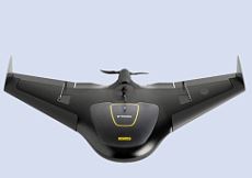
UX5 HP
The Trimble UX5 HP is a professional aerial mapping system, designed to capture the highest image accuracy for survey applications. The features of the new UX5 High Precision will include an integrated Trimble GNSS receiver, a powerful new camera, and a selection of camera lenses for the ultimate in system flexibility. Users can now configure their system for high-precision or increased flight coverage based on project needs.
|
UX5 HP
|
- Orthomosaics resolution down to 1 cm & 3D models with up to 1,000 pts/m2.
- 36 MP, full frame sensor camera ensure better quality images in low light or high contrast situations, allowing in more light and less noise for a greater dynamic range.
- Flexibility to choose between a near infrared or RGB sensor system, and a selection of lenses.
- Capture the highest quality data in difficult conditions.
- Survey quality accuracy without ground control.
- Utilization of PPK GNSS technology to establish image location, ensures time savings in the field.
Image Processing
The Trimble UX5 HP aerial image data can be processed into powerful deliverables with Business Center - HCE Photogrammetry module. Specialized computer-vision algorithms produce very accurate results automatically, with minimal manual interaction. Business Center - HCE provides a stable and reliable photogrammetric system delivering excellent results without requiring specialized photogrammetry knowledge or experience.